Geomapping
At the heart of our mission lies the Biopsychosocial model, a groundbreaking concept developed at the University of Rochester. To truly understand patient populations and the challenges they face, the Data Core established an ongoing Geomapping Project, which takes a holistic view of our community, shedding light on various factors that could influence health care in our area.
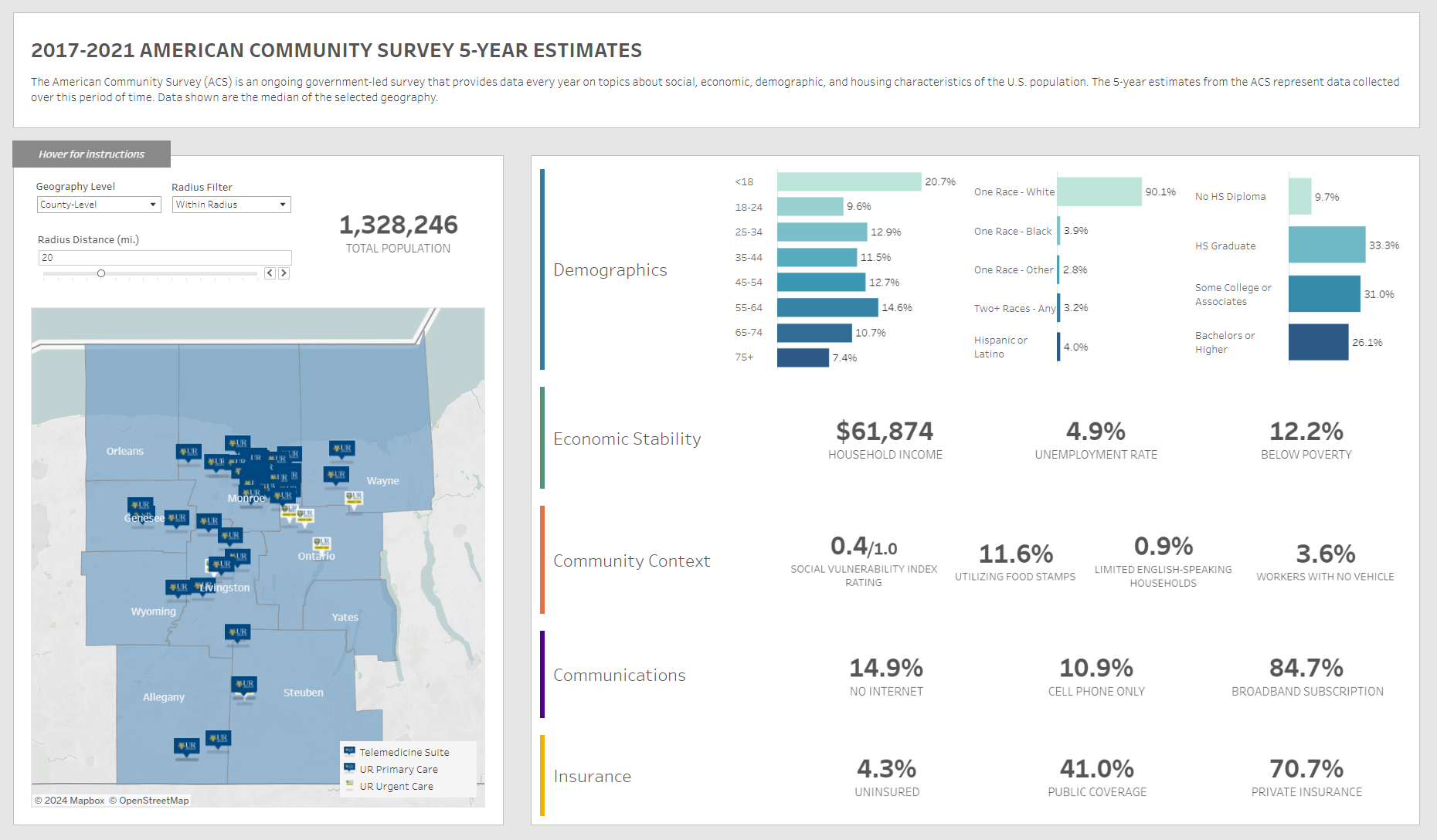
With this project, we gather critical insights by merging geography with data. By integrating the 5-year American Community Survey data into specific geographies, this data reveals crucial aspects of daily life and care, such as insurance coverage, broadband access, income levels, transportation limitations, and poverty rates in areas near UR Medicine facilities. This allows us to:
- Map the Community: We began by mapping UR Medicine Primary Care, Urgent Care, and Telemedicine Suite locations, anchoring them within the broader context of county lines and census tracts. This laid the foundation for geospatial analysis.
- Data Fusion: The team then integrated the 5-year American Community Survey data into the mapped geographies. This fusion of geography and statistics allows us to paint a vivid picture of the community's needs and challenges.
- Patient Insights: Our data team then went a step further by geocoding active patient data. This provides a dynamic view of patient distribution and healthcare utilization.
The Geomapping Project has already yielded a tapestry of insights and possibilities:
- Holistic Understanding: By linking location with demographics, we've gained a more holistic understanding of the community. The team has uncovered disparities in insurance coverage, digital access, income levels, and more, and all are crucial to tailoring current and future care approaches.
- Marketing Mastery: Patient utilization statistics help broader UR Medicine teams target areas with precision, aligning their efforts with patient needs.
- Empowering Choice: Patients now have a continuous voice backed by data, making it easier for individuals to choose the care that suits them best.
- Community-Centered Care: The Geomapping Project helps show that our work isn't just about where our patients are located; this project helps us understand and respond to the needs of our neighbors.
URMC's Geomapping Project transcends mere data analysis; this is a journey of understanding, empowerment, and transformation. The fusion of geography and demographics empowers UR Medicine to provide care that is both top-notch and also considerate of the community's unique challenges and needs. This story of geospatial exploration stands as a testament to URMC's dedication to the Biopsychosocial model, where the "where" and the "who" come together to create a healthcare experience that truly makes a difference.
Contact Us to Learn More